
Asserting Australia's First Nations Sovereignty into Governance
![]()
![]()
![]()
![]()
Search by issue
History (97)
Assimilation & Oppression (181)
Self-determination (91)
Gross Abuse (243)
Sovereignty (199)
Politics (160)
Activism (96)
Culture (117)
Homelands (80)
Genocide (104)
Media Releases (154)
country (78)
Media Releases & News
Sovereign Union Menu
Special Features
Key Topics & Issues
Media & Resources
Activism and Politics

Cooking The Books
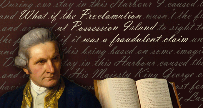
What are the implications if Lieutenant James Cook’s supposed Proclamation at Possession Island is a complete fraud that was concocted later?
What if Cook knew he wasn’t the first European to sight the East Coast of New Holland?
Was Cook’s detailed map of the surrounds of Botany Bay, just a way to verify that it was the same bay as the one on the map given to Joseph Banks that they brought with them?

J. Gibson & T. Brown
Essentially, what was a scientific expedition organised by the Royal Society in 1768 was taken over by the Admiralty, and Cook was put in charge. After viewing the Transit of Venus from Tahiti, they went to map New Zeeland, to see whether it formed part of Terra Australis, which was the thinking of the time. Doing a figure eight around the North and South Islands took six months, so then, short on supplies, they headed to Batavia (Java) , and the quickest way to get there was to fall in with the east coast of New Holland, skirt the coast northwards until they found the passage that separated New Holland from New Guinea.
2020 marks 250 years since “Cook's first voyage of discovery” arrived at Botany Bay. It is from this landing that history has taught that “Australia was discovered in 1770 by Captain Cook.” Of course this was a lie since people were already living on these lands, so it was hardly “discovered” and Cook was not even the first European to see New Holland. There were other Europeans who had charted the northern, Western and even Southern Coasts, but it is still said that Cook was the first European to see the eastern coast, yet even this claim seems highly improbable.
There are early Portuguese Maps from the 1500s, which challenge this assumption of Cook's “discovery”. Indeed, this claim of Cook being the first European discoverer was being challenged over 200 years ago by Alexander Dalrymple who had found copies of these earlier maps in 1762, and had been asked by the Royal Society to lead an expedition to study the Transit of Venus, but was replaced by Lieutenant Cook on orders from the Admiralty, since Dalrymple was not a member of the Royal Navy.
Furthermore, it seems that the “Taking Possession of the whole East Coast” attributed to Cook on Possession Island on 22nd August 1770 was made up afterwards, but whether with or without Cook's knowledge is hard to say. What is clear though, is that such a Proclamation is never mentioned by Joseph Banks in his diary, nor in the Manuscript that Cook delivered in person to his immediate superior Admiral Pallister when he got back to England. Cook's Journal indicates only taking possession of that small “undiscovered” island for his King, not the whole coast of New Holland and nothing about calling it New South Wales.
All other writings from Cook and the crew of the Endeavour were seized by the Admiralty when they arrived back in England, so alterations and insertions most probably occurred either immediately after Cook's return or a few years later.
Lying for the Admiralty
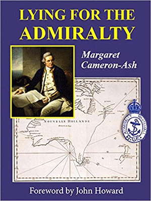
'Lying for the Admiralty'
Paperback by Margaret Cameron-Ash
In 2018, a new book was published about Captain Cook’s Endeavour Voyage. It’s called Lying for the Admiralty, and indeed, it does read as if it’s a cover for the deceptions of the British Admiralty/Crown and that Cook was in on the plan. The overall tone of the book is to laud Cook’s achievements, and if he made any miscalculations, they were intentional so as to deceive European competitors.
What interested me most about this new book is that it concedes that the Possession Island Proclamation Ceremony, said to have been made by Cook on 22nd August 1770 didn’t actually happen. Instead it posits that Cook wrote it into his journal when he got to Batavia, even though the author admits to this theory being based on some imagined scenario occurring there, and offers no actual evidence. The Possession Island Ceremony is mentioned in the Manuscript Cook arranged to be sent back to England when he got to Batavia, as well as in the “official Account” published after Cook had returned. Both of these versions were held by the Admiralty, whereas the one hand delivered to Pallister differs in this regard.
In 2016, Ghillar Michael Anderson had written to the UN questioning the veracity of the Possession Island event, since the Kaurareg People had no oral history of it, and Banks made no mention of it in his diary. Reference: Bottom of page 11 pdf
Ghillar writes:
The initial fraud began in 1770 when Lieutenant Cook failed to take possession with the ‘consent of the natives’:
Notwithstand[ing] I had in the Name of His Majesty taken possession of several places upon this coast, I now once more hoisted English Coulers and in the Name of His Majesty King George the Third took possession of the whole Eastern Coast . . . by the name New South Wales, together with all the Bays, Harbours Rivers and Islands situate upon the said coast, after which we fired three Volleys of small Arms which were Answerd by the like number from the Ship. Reference: 22 August 1770]
Furthermore, despite Cook’s claim of planting his flag on Possession Island in the Torres Strait on 22 August 1770, the oral history of the local people casts doubt that this event ever happened. This is supported by the fact that Joseph Banks, the botanist, who was trained in detailed and precise observations and made detailed records, is curiously silent on this supposedly momentous event.
I followed this up with some further research contrasting the Diary of Joseph Banks, with Cook’s Journal. Reference: Stirring the Pot of the dead Cook
More recently, I went looking for the wording of Cook’s supposed proclamation, and lo and behold, I saw this Wikipedia update about this new book, published in 2018, which agrees that the Possession Island story was a fiction. So I went and borrowed a copy of the book from the local library. Reference: Possession Island (Queensland) Wilipedia
This is from that Wikipedia Page (Screenshot):

References:
2. Beaglehole, J.C. (1955). The Journals of Captain James Cook, Vol.1. Cambridge: Hakluyt Society. p. 387. ISBN 0851157440.
3. Evatt, Elizabeth (1970). ‘The Acquisition of Territory in Australia and New Zealand’, in CH Alexandrowicz (ed) Grotian Society Papers 1968. The Hague: Nijhoff. p. 25.
The Possession Island Proclamation is not mentioned in the Log of Midshipman Bootie either. Reference: (See page 268)
In the copy of Cook’s log held by his friend Admiral Pallister, (there are 3 differing copies of Cook’s Journal, See Footnote (***)) the Possession Island Proclamation is mentioned, however, there’s no mention of New South Wales or of claiming the east coast for his King. It only says that when on that rocky outcrop, now known as Possession Island, it was to get a better view westward,
“A little before sunset, I took possession of the country in His Majesty’s name, and fired three volleys of small arms on the occasion, which were answered from the ship &c.”
Reference Historical Records of New South Wales (n352)
This reads as if Cook only took possession of that island, not the whole eastern coastline of New Holland. It says nothing about the name “New South Wales” or being the first European to see the coast, yet this is from Cook’s Log, as provided to his immediate superior, Admiral Hugh Pallister. It’s probably the least “doctored” account available of Cook’s Journal, since Cook delivered it directly to Pallister on returning to England, whereas all the notes and diaries of the crew were seized by the Admiralty.
In “Lying for the Admiralty”, the author, Margaret Cameron-Ash, has come up with a new story. She asserts that Cook inserted the supposed Proclamation when he got to Batavia (Java) because he feared that the French would claim the east coast of New Holland if the British didn’t. Her book then goes into an imaginary scene in Batavia where Cook had learnt about French explorer Bouganville having been in the area off the east coast less than a year before.
The only evidence offered by Cameron-Ashe to place all the onus on Cook doing this when at Batavia is that the Possession Island Ceremony is also mentioned in the Journals of Zachary Hicks, and James Matra/Magra. Cameron-Ash fails to mention that Hicks died on the way back to England, so his journal could have been doctored once back in England, and that Matra, who was also in the British Navy, was suspected of being the sailor on the Endeavour’s crew who cut off the ears of another crew member. He ended up in diplomatic posts after his returning to England, rather than possibly Court Marshalled, so he escaped punishment somewhat unscathed. Any changes to his diary may have been part of a deal.
Banks, one of the few on the Endeavour not in the employ of the Admiralty, makes no mention of the Possession Island ceremony in his Diary at all, only climbing the rocky summit to get a better view, which is what initially piqued my interest a couple of years ago.
I’m not sure whether Banks would have handed over his diary, or whether Cook’s log he gave personally to his immediate superior would have been handed over, but it seems less likely. To my mind, this is when, if not sometime later, the fictional claim of a ceremony on Possession Island, claiming the east coast, et al, as a “Possession” of the King was inserted into Cook’s Journal. Although Cameron-Ash admits that the wording of this proclamation is far more poetic and out of keeping with anything else Cook wrote, she insists that it was written by Cook’s own hand. Even if this is true, why does she not summise that Cook wrote it on instruction of the Admiralty back in England? It’s widely known that Cook re-wrote parts of his Journal prior to being promoted and sent out again in search of Terra Australis, so why the insistence that Cook inserted the “Possession Ceremony” when he got to Batavia?
Oh that’s right, Cook’s dead, and the Admiralty and the British Crown lives on, still claiming possession of the lands now known as Australia. How convenient for the Crown to blame Cook.
What is also improbable, is that Cook would have handed across to a Dutch Captain, details of his Journal which included claiming the eastern coast of New Holland for Britain. Cook handed across a copy of his Journal, so news could get back to England sooner, since he was awaiting repairs to be done on the Endeavour. This Journal sent via that Dutch Captain was delivered to the Admiralty, and was with-held from the public, just as were the crews' diaries when they got back later, so it was probably altered by the Admiralty as well.
It is noteworthy too, that when arguing for Cook inserting the claim of Possession when at Batavia, the author Cameron Ash writes that Cook was very careful not to impose onto the lands already claimed by the Dutch as New Holland. She says that’s why Cook only claimed from the coast, up to the mountains now called the Great Dividing Range. My reading of the supposed Proclamation is that Cook is said to have claimed the coast and waters, not any land, since he was acting under Admiralty Instruction, which applies to the Law of the Sea and to “undiscovered” or uninhabited islands.
Here’s the 'poetic wording' purportedly from Cook’s Journal
”Having satisfied myself of the great Probabillity of a Passage, thro' which I intend going with the Ship and therefor may land no more upon this Western Eastern coast of New Holland and on the Western side I can make no new discovery the honour of which belongs to the Dutch Navigators and as such they may lay claim to it as their property but the Eastern Coast from the Latitude of 38° South down to this place I am confident was never seen or viseted by any European before ^us andtherefore by the same Rule belongs to great Brittan Notwithstand I had in the Name of his Majesty taken posession of several places upon this coast I now once more hoisted English Coulers and in the Name of His Majesty King George the Third took posession of the whole Eastern Coast from the above Latitude down to this place by the Name of New South ^Wales together with all the Bays, Harbours Rivers and Islands situate upon the same said coast after which we fired three Volleys of small Arms which were Answerd by the like number by from the Ship this done we set out for the Ship”
Reference: Cook's Journal: Daily Entries 22 August 1770 (National Library of Australia)
As to Cook being the first European to map the east coast of New Holland, in the words of M. Barbie du Bocage at the Institute of France in 1807, in reference to earlier Portuguese Maps:
“The English pretend that none of these charts existed until after the death of the celebrated Captain Cook; and they had no knowledge of them when this navigator set sail. But their prior existence in well-known libraries in England may cause this assertion to be doubted”
This is from bottom of page xxiv of the Introduction, here https://archive.org/stream/historicalrecor04walegoog?ref=ol#page/n32/mod...
.As it turns out, Alexander Dalrymple claims he had already told Joseph Banks about these maps in 1768, so when the Endeavour returned from Cook’s first voyage, Dalrymple complained that Cook had made no new discoveries. Cited here, “Dalrymple was on friendly terms with Sir Joseph Banks for many years , as in 1768, he gave him a copy of his Early Discoveries.”

M ieppe Maps, that Dalrymple had uncovered and translated when in Manila working for the British East India Company in 1762.
These early “discoveries” were the Dieppe Maps, that Dalrymple had uncovered and translated when in Manila working for the British East India Company in 1762.
Reference: 16th century maritime map of the east coast of Australia Michael Perry 'Reuters'
That the southern section of the east coast map has the coast jutted out eastward, could account for Cook placing his first sighting of New Holland further east than it actually was, but he would not have been able to accurately calculate his longitude until on dry land at Botany Bay. Cameron Ash never mentions these earlier Maps at all
Note that the southern part of the map has been tuned 90 degrees in the above. See the original here https://nla.gov.au/nla.obj-231809408/view
When looking at this world map from the 1500s, it’s clear that at least the eastern coast of present day Queensland is accurately charted. (Correct longitude notwithstanding)
https://en.wikipedia.org/wiki/Theory_of_the_Portuguese_discovery_of_Aust...
It is these maps that Dalyrmple claims that Banks and Cook knew of before the Endeavour set off from England. See here from the biography of Alexander Dalrymple
An Account of the Discoveries Made in The South Pacifick Ocean, Previous to 1764 (London, 1767). In this work he declared his belief in the existence of a great southern continent, extending into low latitudes in the Pacific; more important, he brought Torres's route to the notice of Joseph Banks. In 1768 it was suggested that Dalrymple should lead the expedition being sent to the Pacific to observe the transit of Venus but his insistence that he should command the vessel was contrary to Admiralty regulations. However, his book provided James Cook with valuable knowledge for his successful navigation of Torres Strait. In his major work, An Historical Collection of the Several Voyages and Discoveries in the South Pacific Ocean (London, 1770), Dalrymple continued to insist that a great southern continent existed. By circumnavigating New Zealand, Cook on his first voyage had imposed severe limitations on this hypothesis, and on his second voyage in 1772-75, he completely disproved it; nevertheless Dalrymple's writings had done much to maintain official interest in Pacific exploration.
http://adb.anu.edu.au/biography/dalrymple-alexander-1949
Although the lands now known as Australia was conflated to be part of the “mythical Great South Land” in the C16th Maps, Able Tasman had dispelled this idea when he sailed south, right across the extent of New Holland, and further east to the western coast of Aotearoa. But Cook's Voyage established that Aotearoa was not part of Terra Australis either. So Cook's 2nd Voyage confined the search to between Aotearoa and South America.
As if the Doctrine of Terra Nullius was applied, 1786/7.
In 1786, after examining the Harleian map in the manuscript collection of Edward Harley, second earl of Oxford, Dalrymple noted: ''The East Coast of New Holland as we name it, is expressed with some curious circumstances of correspondence to Captain Cook's MS.'' Dalrymple drew the conclusion that Cook had apparently not been the first to chart the east coast of Australia. Dr Daniel Solander, the botanist on Cook's first voyage and keeper of the Natural History Department of the British Museum, lent the map to Dalrymple, who saw an opportunity to challenge Cook's priority of discovery of the east coast of Australia.
https://www.smh.com.au/entertainment/the-french-map-that-showed-a-new-wo...
Unfortunately for Dalrymple, 1786 was not a good time to be challenging Cook’s “discovery” since the Crown had already made plans to send convicts to “New South Wales”. Thus, the Crown was wanting to talk up Cook as the great navigator and “discoverer”.
As to the decision in 1785/6 to send Convicts to the land that Cook had mapped the east coast of in 1770, see
http://nationalunitygovernment.org/content/crowns-sneaky-radical-title-s...
The British Monarch still claims Sovereignty over these lands. Like land tenure, this Sovereignty was claimed as if onto a Terra Nullius, but it’s also important to note that the whole legal construct now known as Australia is predicated on lies, half truths and deception, whereas the unceded Sovereignty of the First Nations over these lands remains actual and factual.
In a recent article by Professor Henry Reynolds, even though he presumes that the Possession Island thing did happen, never-the-less he still finds problems with the British claim of Sovereignty
”Cook’s declaration of sovereignty over Eastern Australia at Possession Island in 1770 is a major source of the confusion. There is a widespread belief that it was a defining moment and after that the legal situation was settled, that discovery had, in effect, won half a continent for the British crown. Two serious misconceptions are involved. In a legal sense Cook did not discover eastern Australia. The great 17th century Dutch jurist Hugo Grotius declared that it was shameless to "claim for oneself by right of discovery what is held by another ... for discovery applies to those things which belong to no one".
The second relates to what a claim like Cook’s actually meant. It was an assertion of priority which was directed outward to competing European powers and not inward to the Indigenous nations. The law was succinctly defined by Chief Justice John Marshall in the American Supreme Court in 1832. Such claims of discovery "asserted a title against Europeans only and were considered as blank pages so far as the rights of the natives were concerned".”
https://www.brisbanetimes.com.au/national/strange-situation-why-australi...
But now it seems that no such declaration was even made by Cook.
Re-naming the eastern coast of New Holland as New South Wales.
As to when the use of the term New South Wales was proclaimed for the eastern half of New Holland, it seems that prior to the 1785 Beauchamp Committee, NSW had only referred to a coastal strip, in much the same way as other parts of New Holland were called, variously Arnham’s Land, and what’s now called the Great Australian Bight was called “The land of Pieter Nuyet”, etc. This, as Henry Reynold’s writes “was an assertion of priority which was directed outward to competing European powers”
As an aside, interestingly, when English Orthathologist John Latham documented the New Holland Honeyeater (Phylidonyris novaehollandiae) a honeyeater species presumably brought back by Joseph Banks in 1770, he didn’t name it the NSW honey-eater. It was the first bird to be scientifically described from “Australia”, and was initially named Certhia novaehollandiae (Latham 1781).
As to when the term New South Wales came into official usage, now that it seems that it wasn’t named by Cook on Possession Island in 1770, remains a matter of conjecture. Maps and Charts were amended and confusing.
See Cook’s 1775 Chart here (click to enlarge)
https://upload.wikimedia.org/wikipedia/commons/4/43/James_Cook_-_A_Chart...
It’s looks as if the names New South Wales and New Guinea were added after Cook had already completed his Chart since it is in a different typeface to everything else. Also, the dates of European Discovery use a “long S” for all the other “Difc” dates, but not so for NSW and NG as typed on the Chart.
The western boundary of NSW expanding out from a stretch of coast, ( as depicted on the linked Chart), to suddenly becoming the eastern half of New Holland was made official in Instructions to Governor Phillip, April 1787, but it wasn’t evident on any maps prior to then. It was only documented as a strip along the coast, and even then, maybe not until after the 1776 War of Independence, assuming the naming on Cook’s 1775 Chart was added later.
The Beauchamp Committee, established a decade after that, in 1785, by the UK Parliament to find a new place to dump those who had been sentenced to “Transportation” were initially looking to Das Voltas (Namibia), or else to an island on the Gambian River. Without releasing a final recommendation when that Committee concluded, Parliamentary documents then began referring to “Our Territory called New South Wales”.
The western extent of this “Our Territory” becomes evident in the Instructions to Governor Phillip, 1787, but this is not denoted on any maps prior to this time which all called the continent New Holland, with NSW tagged along a coastline.
Alexander Dalrymple, a hydrographer who worked for the British East India Company, is accredited with having made the first reference to one of the Dieppe maps in his pamphlet Memoir concerning the Chagos & adjacent islands (London, 1786), in which he implied that Cook had known of the existence of the map and used it in his charting of the east coast of Australia. He claimed, for instance, that the Coste de Herbiages (Coast of Vegetation) on the Dieppe map corresponded to Cook's Botany Bay.
from http://www3.slv.vic.gov.au/latrobejournal/issue/latrobe-41/t1-g-t3.html
Earlier Dalrymple had obtained a copy of the Arias Memorial (Spanish) written in 1642, and decided on naming the strait between New Guinea and New Holland as Torres Strait since Torres had sailed through it in 1606.
Clearly, Cook was looking for this strait prior to reaching the tip of Cape York, so he knew of it. It was named Torres Strait by Dalrymple in his book “ Historical Collection of the Several Voyages and Discoveries in the South Pacific Ocean “ published in 1770, just when the Endeavour was returning to England, thus that name was not used in Cook’s Journal.
Dalrymple’s Book published in 1770, which in it’s preface begins with “Above two years ago I printed a few copies of a tract on ‘The Discoveries made in the South Pacific Ocean’, however I did not publish til lately when it was reported that the French had discovered the continent.”
Then at preface page xv “I confined myself to the discoveries made between SOUTH AMERICA and PAPUA. “ This Preface is dated July 1, 1769.
The full online book is available here https://archive.org/details/cihm_35630/page/n15
Was it that Cook was just verifying and amending the Spanish and Portuguese maps, when charting the eastern coast of New Holland, and with the calculations of astronomer Charles Green, giving more accurate Longitude readings, rather than "discovering" something otherwise unseen by any European?
If Cook knew that he was not the first European to see the east coast, nor first to chart it’s features, he would still have needed to descriptively name the geographic features he saw, to use as survey points when charting the coast when still at sea. So he wasn't so much “naming” these geographic features, more so identifying them for his own and future reference. The only documented time Cook was said to have claimed to be the first (European) “discoverer” was in that dodgy Proclamation on Possession Island, but there's little evidence he was attempting to claim convenient situations along the coast as in “discovering” when he was actually charting it.
Clearly the political/legal construct now known as Australia is all based on fraud, and without legal foundation.
The subsequent mass murders and dispossession of the True Sovereigns of these lands is an ongoing criminal act, basically because the British elite had grown accustomed to off-shore detention as the means for maintaining the appalling social conditions in England, where the extremely wealthy few wanted to expel the impoverished troublemakers, so as to keep their own privilege secure.
The First Nations’ Peoples here then became “collateral damage” because the British didn’t bother to abide by their own laws of garnering the “Consent of the Natives” via Rentals, Purchases or Treaties on newly discovered lands (See Royal Decree of 1763, and Secret Instructions to Cook, etc) The Crown presumed sole ownership of the lands, while still in England, because they were panicking about how to maintain their social and political system of extreme disparity, and with certain men’s careers, especially Lord Sydney’s, on the line.
(see Beauchamp Committee here http://nationalunitygovernment.org/content/crowns-sneaky-radical-title-s... )
The Crown relied on some “manufactured Consent” by instructing Governor Phillip to treat the Natives with amity, and then later to “civilise”(sic) Bennelong and Colebee, take them back to England, and parade them around dressed in finery, to show their consent of being “discovered” and “saved from themselves”. This was trickery, not treaty, but it served a purpose since it gave the impression of “Consent” to folks in England.
It is because of these illegal acts by Britain, that the unceded Sovereignty of the First Nations is yet to be acknowledged.
It is because of these illegal acts by Britain that Her Majesty’s Governments here keep trying to find ways to finish off their Terra Nullius project.
It is because of these illegal acts by Britain that British Subjects here were put on a collision course with the True Owners of the lands, with imposed laws that treated the True Owners as being less than human.
It is because of these illegal acts by Britain that Governments here are still pushing their latest genocidal technique of including and subsuming Aboriginal and Torres Strait Islander Peoples into their dodgy Constitution, and to do so with the perceived “Consent of the Natives” as some tokenistic “Voice” to Parliament.
Here are some further historical anomalies which suggest that Cook may have known full well that he was not the first European to visit the east coast of New Holland.
In 1912 Lawrence Hargraves discovered carvings on the foreshores of Botany Bay. The carvings depict letterings and 2 outlines of a Carrick, a vessel steered by a sweep, like an ancient Greek trireme. It resembled the ‘santa maria’ in which Columbus sailed to America in 1492. The letterings in capitals beside the ship were BALN. On one line and beneath ZAIH. The letter W was beside the symbol of a cross with and elongated circle. The symbol of intended conquest by Spain. It was emblazoned on the sails of the Spanish Armada and the ships of the Conquistadors. Hargrave translated the Spanish Latin doodles to read "We in the Santa Barbara and Santa Isobel conquered W from point to point by the sign of the cross. AIH could have been the rock signatures of witnesses to the declaration. In the same area, Hargraves also examined 2 stout rings bolts leaded into solid rock near the waters edge, far enough apart to hold ropes attached to the mast of a small ship.
It is also possible that these were were done by the Gadigal People.
Could it be that Cook landed at Botany Bay to verify that it was the same bay that was depicted in the map mentioned (and perhaps provided) by Dalrymple, which is why he made such an extensive map of the surrounds? ?
Dalrymple certainly thought so.
"Alexander Dalrymple is accredited with having made the first reference to one of the Dieppe maps in his pamphlet Memoir concerning the Chagos & adjacent islands (London, 1786), in which he implied that Cook had known of the existence of the map and used it in his charting of the east coast of Australia. He claimed, for instance, that the Coste de Herbiages (Coast of Vegetation) on the Dieppe map corresponded to Cook's Botany Bay."
from http://www3.slv.vic.gov.au/.../issue/latrobe-41/t1-g-t3.html
Further theories about other European encounters with the east coast are here
http://www.mysteriousaustralia.com/carving_a_new_history.html?fbclid=IwA...
These lands were not a Terra Nullius in 1788 even though the Crown instructed their Governors to treat the lands as such by denying Property and Cultural Rights to the True Sovereigns of the soil. That the Crown’s presumption to the lands is premised on lies, deceit and re-writes of Cook’s Journal shows the depth of the deception. Even if Cook had done what we were taught as history, and been first European “discoverer”, this gave Britain no right to claim the lands from those whose lands it is, and to grant the lands out to others. To find that Cook made no claims to have “in the Name of his Majesty taken posession of several places upon this coast I now once more hoisted English Coulers” makes the deception and criminality even more heinous, and exposes Australia to be without legal foundation.
Dalrymple’s Accusation
After first sighting New Holland at Point Hicks, Cook charts the coast northwards, sails straight passed Two Fold Bay, one of the best natural deep water harbours in the world, tries to land near Bateman's Bay, then finally lands at Botany Bay, as if he was making a bee line for it, where he does an extensive map of the immediate area.
After staying six days at Botany Bay, Cook's Journal mentions having flown the English Colours each day they were there, and some inscriptions were carved into a tree. This Journal entry looks like an addition included much later too, and no other time does Cook's Journal mention flags being hoisted except at Passage (Possession) Island. After leaving Botany Bay, Cook again sails north, passing Port Jackson, and seemingly with no intention of landing anywhere else along the whole east coast. There are brief stops near Gladstone (Seven Seventy, Ql’d) where some of his crew go ashore in search of fresh water but Cook stays on the ship, and again, some crew go to search for fresh water just south of present day Cooktown, but not to stop over for a few days, nor to investigate the area.
.
Travelling further north again, they soon hit a reef, and the Endeavour hobbles into “Endeavour River”, Cook Town, in Far North Queensland where they remain for over six weeks to make repairs, but this was not an intended landing.
Those are the only times, Cook or any of his crew ever set foot on New Holland. Botany Bay is the only place Cook had quite intentionally wanted to land, and is where he also decides to get a detailed map of the area. Everything else done by Cook are Charts of the coast and the adjacent islands and reefs.
It’s as if Cook was specifically looking for Botany Bay, (or Coste de Herbiages (Coast of Vegetation) on the Dieppe map) which is exactly what Dalrymple asserted in 1786.
Then, after traversing Torres Strait on August 22nd, and entering the Arafura Sea,
On August 28th, 1770, on expecting to see New Guinea by now, Cook’s Journal entry states
”We were now by Observation in the Latitude of 8 degrees 52 minutes South, which is in the same Parrallel as the Southern parts of New Guinea as it is laid down in the Charts; but there are only 2 points so far to the South, and I reckon we are a degree to the Westward of both, and for that reason do not see the Land which trends more to the Northward.”
Perhaps this is the Chart Cook refers to, since it was published in London in 1759 https://nla.gov.au/nla.obj-232677820/view
Note the east coast of Cape York is on this Map, and remember that longitudes or even approximate longitudes were very complex to calculate before 1772, which may account for the angle being a bit skewiff.
Cook must have had a copy of the linked Chart, or one much like it, since the Chart depicts, (right below the axis of the radiating lines) C.St. Bonaventura, since on September 3rd, 1770,Cook writes
”65 leagues to the NE of Port St Augustino, near C. de la Colta de Sa Bonaventura”.
So Cook was already familiar with the name Cape St Bonaventura.
Cook’s Diary then continues about some small islands they see on Sept 5th
“These islands have no place on the Charts, unless they are the Arrow Islands, which, if they are, are laid down much too far from New Guinea.”
What other Charts did Cook have with him?
especially as no new discovery can be expected to be made in those seas which the Dutch have I beleive long ago narrowly examined, as appears from ^3 Maps bound up with the French History of Voyages to the Terra Australis, published in 1756, which Maps I do suppose by some means have been got from the Dutch as we find the names of many of the places are in that Language. It should likewise seem from the same Maps that the Spaniards and Dutch have at one time or a nother circumnavigated the whole of the Island of New Guinea as the most of the names are in these two Languages, and such part of the Coast as we have been ^were upon I fo^und the Chart tolerable good which obliges me to give some Credit to all the rest notwithstanding we neither know by whome or when they were taken, and I allways understood before I had a sight of these Maps that it was unknown whether or no New-Holland and New-Guinea was not one continued land, and so it is a said in the very History of Voyages these Maps are bou^ntd up in; however we have now put this wholy out of dispute but as I beleive it was known before tho' not publickly I clame no other merit than the clearing up of a doubtfull point.
Notes on calculating Longitude
It was not until Cook's 2nd Voyage that he had a chronometer, an exact time keeping clock, which simplified calculating longitude, using Greenwich Mean Time compared to noon by the sun.
On Cook's First Voyage, they relied on studying the angle between the moon and certain stars as tabled on a Euphemeris. Thus, it was impossible to accurately determine longitude when night skies were cloudy.
See here for further details
https://maas.museum/observations/2007/07/25/how-captain-cook-found-his-l...
Footnote (***)
The Mitchell MS runs from the beginning of the voyage to 23 October 1770, at Batavia, and is clearly the copy that Cook sent home to the Admiralty Secretary from that port. The Admiralty MS is complete for the whole voyage—indeed it has one final entry not in the Canberra MS—and is equally clearly the full copy handed over by Cook when he reached London. The third copy of the original was in the Royal Library at Windsor Castle, and was presented to the National Maritime Museum at Greenwich by King George V in 1935. I call it the Greenwich MS. When I assembled the microfilms and did the collating I found it was a queer, a maddening amalgam: for it is not a straightforward copy of the journal at all. It is partly log, partly journal, in three or four different hands, and ends up as a very bad and careless copy altogether.
We know he must have done so, because that is the only way the Admiralty copy could have come into existence—something must have been there to copy, the clerk didn't invent a version, and this version is different in some places from everything else. Let me call it X. X in Cook's handwriting has disappeared. But we have a third version of the journal, and in Cook's hand, with what he thought necessary compression and with gaps filled in. This is now in the British Museum, Add. MS 27888—88 for short. From this the Greenwich copy was made. Then, after Cook reached England, and found he was to write the official account, he got to work on it and revised it heavily, rewriting entire sections, incorporating footnotes, adding marginal passages in the light of after-knowledge, transferring paragraphs, drafting new sentences or paragraphs on separate scraps of paper and labelling them A and B—all tricks familiar to the author in gestation; and finally took to the thing with red ink. It is an extraordinary mixture, as it is all bound up, rewritten sections following or preceding the original ones, interpolated scraps in the wrong places, marginal passages in red ink continued four pages earlier, and so on.
from http://nzetc.victoria.ac.nz/tm/scholarly/tei-BeaSome-t1-body1.html?fbcli...
Here's another map https://upload.wikimedia.org/wikipedia/commons/6/63/Harleian.jpg
- - - - - - - - - - - - - - - - -
Researched by Graeme Taylor, whitefella ally and supporter of Sovereign Union
16 December 2019