
Asserting Australia's First Nations Sovereignty into Governance
![]()
![]()
![]()
![]()
Search by issue
Sovereignty (199)
Gross Abuse (243)
History (97)
Genocide (104)
Media Releases (154)
Assimilation & Oppression (181)
Culture (117)
Self-determination (91)
Politics (160)
Homelands (80)
Activism (96)
country (78)
Media Releases & News
Sovereign Union Menu
Special Features
Key Topics & Issues
Media & Resources
Activism and Politics

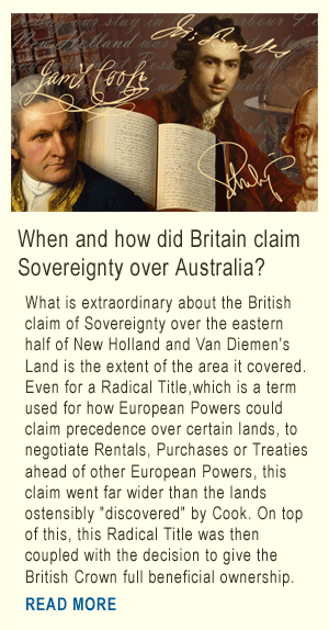
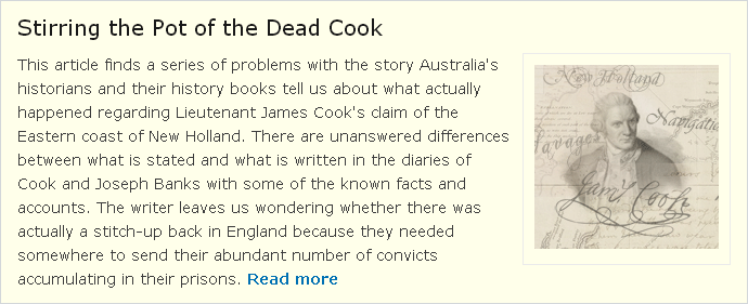
'Over Cooked': Is Captain Cook the source of British sovereignty in Australia?

Captain Cook's ship laid on the shoreline of the northern coast of New Holland (now Cooktown Queensland) for hull repairs.
(Background image: 'The Endeavour', c 1770. An engraving by Rennoldson)
The story of Lieutenant James Cook and British Sovereignty over Australia has been overcooked. At no time on any of Cook's three voyages to the Pacific was he intending to go anywhere near New Holland. He did chart the east coast of New Holland in 1770, but that was not part of his Instructions.
The whole story about Cook and his association with the claim of British Sovereignty over the lands now known as Australia is retrospective, rather than consistent with the events of the time.
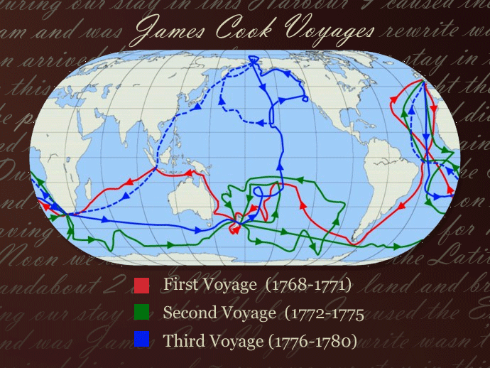
Cook's initial "mission" was to get to Tahiti to study the Transit of Venus, and to then look for the fabled Great Southern Land, Terra Australis. In Europe, they believed that this unknown land mass was either extending east from Aotearoa (New Zeeland) or further east closer to South America. They already knew that New Holland was not part of Terra Australis.
- - - -
When Cook was heading home after mapping Aoteroa (Which Tasman had named New Zeeland) Cook wanted to go back the same way as they came, back around the south of South America, but because of the battered condition of their ship, other officers on board convinced him to travel to Batavia, (Java) to get repairs to the boat and more supplies. The quickest way to do so was to fall in with the east coast of New Holland, and travel northward, up to the strait that separated New Holland from New Guinea, turn left and head straight to Batavia.
Cook also believed that by going back towards South America, he was more likely to discover the mythical Terra Australis.
Cook had no intention of going anywhere near New Holland. After mapping New Zeeland and still wanting to search for Terra Australis, as per his Instructions, (the mythical Great South Land), Cook refers to having to sail "in a high latitude" before going back around Cape Horn, South America,"high latitude" means further south which is a higher latitude south.
Here's what Cook's Journal entry for 31st March 1770,
"Upon my return to the Ship in the evening I found the Water &Ca all on board and the Ship ready for sea and being now resolv'd to quit this country altogether and to bend my thoughts towards returning home by such a rout as might conduce most to the advantage of the service I am upon I consulted with the officers upon the most eligible way of putting this in execution. To return by ^the way of Cape Horn was what I most wish'd because by this rout we should have been able to prove the existence or non existence of a Southern Continent which yet remains doubtfull, but in order to ascertain this we must have kept in a high latitude in the very depth of winter ^but the condition of the ship in every respect was not thought sufficient for such an undertaking. for the same reason the thoughts of proceeding directly to the Cape of Good Hope was laid a side especialy as no discovery of any moment could be hoped for in that rout it was therefore resolved to return by way of the East Indies, but as the state of the Ships provisions was thought more than sufficient to carry us thither it was agree'd ^by the following rout - upon leaving this coast to steer to the westward untill we fall in with the East Coast of New Holland and than to follow the deriction of that Coast to the northward or ^what other direction it might take untill we arrive at its northern extremity and if this should be found ^impractical than to endeavour to fall in with the lands or Islands discover'd by Quiros. "
Cooks Journal Entry 31 March 1770 National Library of Australia
So on advice from his officers Cook sailed west towards New Holland.
After sighting New Holland (Australia), they turned starboard (northward) and mapped the coast for 350 kms, going straight past Two Fold Bay and then deciding against landing at Bateman's Bay, then going another 250kms before eventually landing at Stingray/Botany Bay where they stayed for a week collecting fresh water, timber and catching fish.
Cook, in what gets described as his meticulous Journal writing, doesn't mention anything about planting a flag, nor any act of taking possession for Britain, until the day after they leave Botany Bay, where his Journal entry records
"During our stay in this Harbour I caused the English Colours to be display'd a shore every day and an inscription to be cut out upon ^one of the trees near the watering place seting forth the Ships name, date &Ca"
More details here: Cooks Journal 6 May 1770 National Library of Australia (Near the bottom of the page)
This is the only time that Cook ever writes of "planting a flag" on the mainland of New Holland, and Botany Bay is the only place he intended to land on the mainland. He did of course end up landing again at Cooktown for emergency repairs to the boat after hitting the reef, but that was not a planned visit. On two other occasions he sent a couple of crew members ashore to search for fresh water, first at present day Seventeen Seventy, (near Gladstone) and again near Cairns, but there's no mention of flag raising then, nor of any flag raising at Waalumbaal Birri (Endeavour River Far North Queensland) where they were stuck for over six weeks, busy getting their boat sailable again.
Yet his Journal records that when they got to what he initially called Passage, but later changed to Possession Island, there's this supposed Proclamation
"Notwithstand I had in the Name of his Majesty taken posession of several places upon this coast I now once more hoisted English Coulers and in the Name of His Majesty King George the Third took posession of the whole Eastern Coast from the above Latitude down to this place by the Name of New South ^Wales together with all the Bays, Harbours Rivers and Islands situate upon the same said coast after which we fired three Volleys of small Arms which were Answerd by the like number by from the Ship"
This proclamation is not mentioned in the diary of Joseph Banks at all, even though Banks is said to have accompanied Cook onto Passage (Possession) Island to get a look to see if they were in another bay, or in the strait separating New Holland from New Guinea.
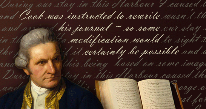
The most likely scenario is that when Cook and crew got back to England, the Journal entry about flying the flag at Botany Bay, and the proclamation at "Possession Island" were inserted into Cook's Journal. Since the Admiralty seized all of the writings of the crew when they got back to England, and Cook was instructed to rewrite his Journal, such a doctoring (modification) was quite likely. Because Banks was a private paying passenger, his Diary is most likely to be the least altered version of events. Interesting too, that a private copy/version of Cook's Journal that he gave personally to his immediate superior, Admiral Pallister, doesn't mention any big proclamation on Possession Island, only the taking possession of that small island itself.
The probable motive for altering Cook's Journal was that the Admiralty, on learning of French "Explorer" Bouganville having sailed near Cairns but outside the reef, the year before Cook sailed by, made the British Admiralty fear that the French might try to claim the east coast of New Holland for themselves. Ever since, there's been this major publicity campaign to aggrandise Cook as the greatest ever navigator and discoverer, yet even Cook's supposed claim of being the first European to sight the east coast has been contested in Europe, from when it was first made.
Cook knew full well that New Holland was not "the land of great extent" which is why his 2nd voyage focused east of Aotearoa, the area he wanted to sail back through after mapping New Zealand. The only "evidence" of Cook claiming the east coast of New Holland are in two Journal entries, 6th May where he retrospectively writes of having planted the flag each day, and carving initials in a tree, (yet no-one says they've seen such carvings from 1788 to now), and then later the Possession Island thing. No mention of flag planting in 7 weeks at Cooktown, nor at 1770 (near Gladstone) or just south of Cairns when some crew members went ashore looking for fresh water. So from his actions and words, it seems clear that it was not Cook's intent to claim convenient situations along the coast, nor to claim the whole east coast for his King when navigating along the coast. My guess is that that happened back in England, when the Admiralty found out about Bouganville, so they got Cook to insert an entry in his journal and they also changed things in the diaries of the crew.
Alexander Dalrymple, the Royal Society's choice to captain the voyage, but replaced by navy man Cook, thought that the west coast of NZ might be the west coast of Terra Australis, but Cook proved otherwise. This perhaps was Cook's greatest achievement.
Cook is also touted as a great Cartographer, but on board the Endeavour was the Royal Society's Assistant Astronomer Charles Green, who could do all the fine detailed calculations of the planets and moon, which were needed to determine longitude before the invention of the chronometer. Sadly, Charles Green has been largely forgotten since he died of Malaria, along with 7 or 8 other crew members, when the Endeavour was in Batavia getting repaired with the help of the Dutch East India Company. Cook took a chronometer on his subsequent voyages.
More details here: Cooking the books Sovereign Union
Cook offered praise to Astronomer Charles Green, but this seems to have been largely forgotten from the narrative that praises Cook as the great navigator. From Cook's Journal 23rd August 1770
"... In justice to Mr Green I must say that he was Indefatigable in making and calculating these observations which otherwise must have taken up a great deal of my time, which I could not at all times very well spare. Not only this, but by his Instructions several of the Petty officers can make and Calculate these observations almost as well as himself: it is only by such means that this method of finding the Longitude at Sea can be put into universal practice, a method that we have generally found may be depended upon to ^within half a degree; ^which is a degree of accuracy more than Sufficient for all Nautical purposes."
From: Cook's Journal 23 August 1770 National Library of Australia
Another oddity in the story is that Cook's Journal speaks of it not being widely known whether a strait exists between New Holland and New Guinea, but back in England Alexander Dalrymple had managed to get this strait named in honour of the Spanish seaman Lois Vaez de Torres who had charted it in 1606. Oops.
PS At best, Cook is said to have claimed a coastline in 1770, yet in Instructions to Governor Phillip 1787, he is to be Lieutenant Governor of the eastern half of the continent, as far south as the bottom of Van Diemens Land, even though Cook never went near there, and to the tip of Cape York, from the coast said to be claimed by Cook, as far west as a longitude that cuts New Holland down the middle.
The "official" version of events we have been told, posits that Cook proclaimed the East Coast of New Holland to be a coast of Britain, a few weeks before he was desperately hoping to get his boat repaired by the Dutch East India Company in Batavia. This makes no sense." Could you fix my boat please? By the way, I've just stolen your coast." The proclamation looks especially odd considering that Cook didn't even want to go anywhere near New Holland when leaving New Zeeland, but decided to, only so as to get to Batavia for repairs.
The President of the Royal Society offered these Instructions to Lieutenant Cook in 1768.
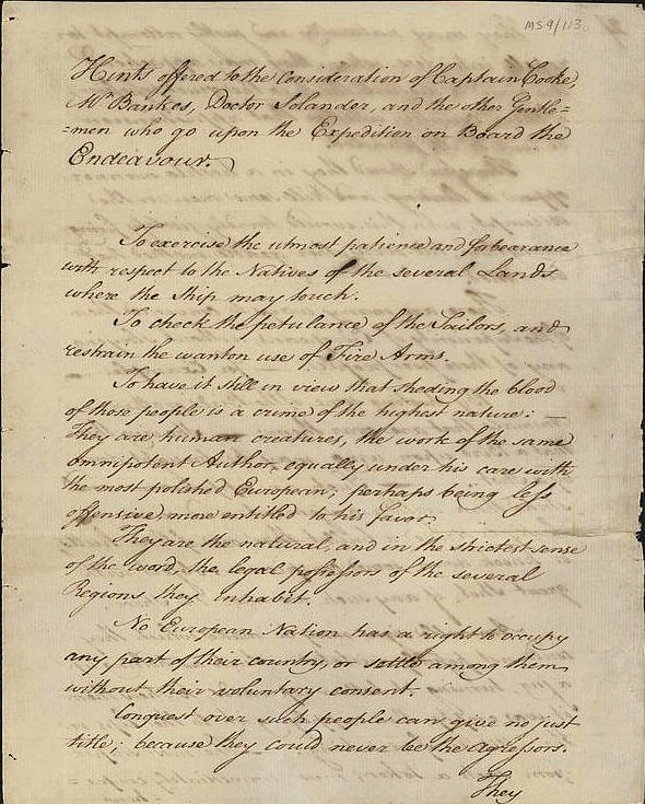
'Hints offered to the consideration of Captain Cook, Mr. Bankes, Doctor Solander and other gentlemen who go upon the expedition on board the Endeavour. Chiswick, 10 August 1768.'
- To exercise the utmost patience and forebearance with respect to the Natives of the several Lands where the Ship may touch.
- To check the petulance of the sailors and restrain the wanton use of Fire Arms.
- To have it still in view that sheding the blood of these people is a crime of the highest nature;- They are human creatures, the work of the same omnipotent Author, equally under his care with the most polished European, perhaps being less offensive, more entitled to his favour.
- They are the natural, and in the strictest sense of the word, the legal possessors of the several Regions they inhabit.
- No European nation has a right to occupy any part of their country or settle among them without their voluntary consent.
- Conquest over such people can give no just title, because they could never be the Aggressors.
- It is natural for them to defend their land and if they are hostile there are to be no reprisals.
Detailed suggestions are given on how to approach the natives peacably. The primary object of the expedition is to observe the transit of Venus. Once this has been achieved, attention can be turned to other matters "particularly the discovery of a continent in the lower temperate latitudes".
James Douglas, 14th Earl of Morton, Chiswick, 10 August 1768.
Notes for Cook, Banks, Dr. Solander and the other gentlemen who go upon the expedition on board the Endeavour.
Cook's Journal of March 31, 1770, reiterates this purpose. (see above)
Because the general thinking in Europe at the time was that the discovery of a continent in the lower temperate latitudes was the reason Cook wanted to go back across the Pacific toward South America, looking further south than how they had travelled to New Zealand, which was via Tahiti.
It thus seems illogical that Cook would then claim the East Coast of New Holland, since it had nothing to do with his Instructions. He had no intention of going there except to get to Batavia for repairs.
Research by Graeme Taylor
- - - - - - - - - - - - - - - - - - - - - - -
NOTES
Although Cook’s Journal for his Second Voyage was published in 1777, the Journal/s of his first voyage were not published, or known to the public, until much later, well after 1786 and the claim of "Our Territory called New South Wales".
What was available was the "Hawkesworth Version", a compilation of Cook, Banks and Solander's writings called " Round the World Vol 2 Lieutenant Cook's Voyage" (page 37/438, and 244/438 where the Possession Island Proclamation is included)
Source: Captain Cook Society
This was published in 1773, seemingly without input from Cook during the process, since Cook was away again in the Pacific on hise 2nd Voyage, again in search of Terra Australis.
Cook was reportedly not happy about this amalgam publication and insisted on doing his own editing for the Journal of his Second Voyage, which was published soon after.
As to Cook's Journal/s of his First Voyage, (there were triplicate made) when they were made available,
In the Preface written by CAPTAIN W.J.L. WHARTON, R.N., F.R.S. Hydrographer of the Admiralty. in 1893. in what is regarded as Cook's Official Journal, he states "The two first-mentioned Journals are in the handwriting of an amanuensis, Mr. Orton, the clerk. No autograph journal is, so far as is known, in existence, but some rough original must have been kept, as both copies bear internal evidence of having been written up after the lapse of an interval after the events described.
This is markedly the case in the Australian part of the Journal."
Source: Hathi Trust - An Account of Cook's Voyage

It's how much later that things were "written up" which is the unknown.
According to the "Postscript" written by Cook at the end of his first voyage in this "Official Version", he writes that when they got to Mauritus, he heard that French navigator Bouganville had plans for getting 100 troops and of making a settlement in New Zealand.
See this page where Holland is crossed off and Zeland was written in instead, so Cook was worried about the French, but not in relation to New Holland.
Cook is back in England when writing this Postscript, and is still using the term New Holland, even if amending it to New Zealand.
From the Historical Records of New South Wales, Vol. I, Part I—COOK. 1762—1780. By Authority. SYDNEY:CHARLES POTTER, GOVERNMENT PRINTER. 1893
"A little before sunset I took possession of the country."
See bottom of page here
This appears to be about taking possession of “Passage” (Possession) Island.
See bottom of page here
This is also what Midshipman Bootie mentions occurred, as well as in Cook’s private diary given to Pallister.
Now here’s a quote from the Historical Records book.
It is a remarkable fact that nowhere in the original papers of either Cook or any of his officers does the name “ New South Wales” appear.
As in the case of “ Botany Bay,” it seems to have been an after-thought.
The first mention of “New South Wales” in the text of Hawkesworth’s voyages occurs in vol.iii, at p. 616, where, under date the 21st August, 1770, we find the following entry '“As I was now about to quit the eastern coast of New Holland, which I had coasted from latitude 30 to this place, and which lam confident no European had ever seen before, I once more hoisted English colours, and though I had already taken possession of several particular parts, I now took possession of the whole eastern coast from latitude 38 to this place, latitude 10| S., in right of his Majesty King George the Third, by the name of New South Wales, with all the bays, harbours, rivers, and islands situated upon it. We then fired three vollies of small arms, which were answered by the same number from the ship.”
This ceremony is described in both the private and official logs of Cook, ante, pp. 78 and 157, and also in the logs and journals of Lieutenant Hicks, Norwood, Bootie, and in four anonymous ones; but none contain any mention of either “New South Wales”or “New Wales.” Hawkesworth is singularly careless in the use of the name.
Except in the headings to chapters 1, 8, and 9 of Book 111, it only occurs twice—once on p. 616, as quoted above ; and, again, on p. 622, where he refers to “New Holland, or, as I have now called the eastern coast, New South Wales.”
It is always New Holland, except on pp. 620 and 649 (vol. iii), where he calls it “ New Wales.”
It will be seen from the above that there is no foundation for the popular impression that Cook bestowed the name “ New South Wales ”on the territory, in consequence of a fancied resemblance of the coast-line to parts of the coast of South Wales. It is evident that, if Cook had taken possession of the country by the name of New South Wales (as stated by Hawkesworth), reference would have been made to it somewhere in the many original logs or journals.
The name appears to have originated with Hawkesworth. Cook had been content with “ the east coast of New Holland.” His editor, apparently, was desirous of being more precise; and, as the map of the world then contained a New Britain, New England, New Scotland, New Ireland, New North Wales, New Guernsey, New Denmark, New Holland, New Jersey, New Zealand, and scores of others (all according to this theory resembling the originals), he selected, probably, the best that was left, when he called it New South Wales.
It is very remarkable that Cook, during his long voyage round New Zealand, and along the east coast of New Holland, did not once resort to this very easy method of disposing l, of the difficulty of finding names for his discoveries. He does not use the word “ New ” once.
If this was intentional, it very greatly strengthens the contention that the name “New South Wales ” originated with Hawkesworth. It must be borne in mind that at the time when Cook’s editor (Hawkesworth) published the account of this voyage Cook was, and had been for about twelve months, absent on his second voyage round the world.
all taken from that Historical Records book, see here
https://nla.gov.au/nla.obj-343226933/view?sectionId=nla.obj-348109225&pa...
There is also no mention of hoisting the English colours at Stingray (Botany Bay) from 29th April to May 7th. Here
https://nla.gov.au/nla.obj-343226933/view?sectionId=nla.obj-348109225&pa...
Attention has been frequently called to the fact that in a French copy of an old chart-of date between 1530 and 1536-a part of the Eastern Coast of New Holland, not far north of the latitude of Botany Bay, is designated "Coste des Herbiages" (the coast of plants and pastures). This chart was originally in the possession of Edward Harley, Earl of Oxford and on his death, in 1724, was stolen by one of his servants. Sir Joseph Banks subsequently discovered and purchased it-but at what date is not known-and in the year 1790 presented it to the British Museum. If, as is very probable, he purchased it shortly after his return to England, and while Hawkesworth was compiling the account of the voyage, his interest in the publication would naturally lead him to suggest the adoption of the anglicised forms of any names on the old chart, which he might regard as more appropriate than those bestowed by Cook.
Dalrymple, who first called attention to the coincidence, drew conclusions not very flattering to Cook. The subject is dealt with by R. H. Major in his Early Voyages to Terra Australis.(published in 1859) p xxx11, where he quotes at lenth, and with appropriation, a warm defence of Cook from the pen of M. Frederic Metz.
Bottom of page 161, here https://archive.org/stream/historicalrecor04walegoog?ref=ol#page/n214/mo...
Here is some of that information
The atlas now in the possession of Sir Thomas Phillipps, which as we have stated, is probably next in date to that made for the Dauphin, fell into the possession of Prince Talleyrand at the beginning of{Page: xxxv} this century, and attracting the attention of the celebrated geographer M. Barbie du Bocage, drew from him the following notice in the 'Magasin Encyclopedique, douzieme annee', tom. iv, 1807, which, though lengthy, bears so directly upon the subject of the present work, that it is here given in full.
Extract from the notice of a geographical manuscript belonging to his Serene Highness the Prince of Benevento (better known as Prince Talleyrand), read at a public session of the Institute, on the 3rd of July, 1807, by M. Barbie du Bocage.
"This manuscript is an hydrographic atlas, drawn at Dieppe in 1547 by a person of the name of Nicholas Vallard, of Dieppe, representing the eastern and western coasts of the continent of New Holland. This atlas is not the only one upon which these coasts are laid down. There are two in England, which came from France, and which we have been acquainted with by the English as well as by some Frenchmen. One of the two, which has been for a considerable time in the library of the British Museum, was drawn in 1542 by a person of the name of Jean Rotz or Roty, who had in the first instance drawn it, as he states in the dedication, for the King of France, but afterwards presented it to Henry VIII, king of England. The second is a large map on one single sheet of parchment, made for the Dauphin of France, whose arms it bears. It was formerly in the library of the Earl of Oxford, where Sir Joseph Banks was acquainted with it, and thence it passed to the British Museum, where it is at present. The English pretend that none of these charts were discovered till after the death of the celebrated Captain Cook, and that they had no knowledge of them when this navigator set sail. But their prior existence in well-known libraries in England may cause this assertion {Page: xxxvi} to be doubted. But even if they had made use of them to indicate to their countryman the countries which he had to visit, it would not the less follow that the skill the prudence and the resolution with which Captain Cook conducted his operations must always secure for him the glory of having made known in detail the countries which had hitherto been but faintly indicated."
The third manuscript atlas which represents the coasts of New Holland is that of which we have now to treat. It is a small folio volume, consisting of fifteen hydrographical charts on vellum, which has been recently acquired by his serene highness the Prince of Benevento. This atlas, even by the account of persons who have seen those which are in England, is the most beautiful of all the works of the kind, and for this reason deserves the most particular attention. There has since been discovered in France a fourth which is at present in the library of the Depot de la Guerre, which was drawn in 1555 by a person named Guillaume le Testu, a pilot, of Grasse, in Provence, for Admiral Coligny, to whom it is dedicated, and whose arms it bears.
The English geographers, MM. Dalrymple, Major Rennell, and Pinkerton; and among the French, MM. Bauache, De la Rochette, Coquebert de Montbret, and others, recognise on these atlases the eastern and western coasts of New Holland. These coasts are bounded by the same latitudes as those indicated on recent maps; and if they encroach more on longitude it is because, at the time the discovery was made, there existed but small means of fixing the boundaries in that respect. The names on all the atlases which we have just quoted are, for the most part, in Portuguese, some of them in French; that of 1542 alone, which is in England, has some of the names in bad English. We must, therefore, come to the conclusion that these atlases have been copied from Portuguese maps, and consequently that the discovery of the continent of New Holland belongs to the Portuguese.
http://gutenberg.net.au/ebooks06/0600361h.html
Joseph Banks account of the situation when leaving Aotearoa (New Zealand) on March 31, 1770
”Having now intirely circumnavigated New Zealand and found it, not as generaly has been supposd part of a continent, but 2 Islands: and having not the least reason to imagine that any countrey larger than itself lays in its neighbourhood, it was resolvd to leave it and Proceed upon farther discoveries in our return to England being determind to do as much as the state of the Ship and provisions would allow. In consequence of this resolution a consultation was held and 3 schemes proposd: One, much the most elegible, to return by Cape Horn keeping all the way in the high Latitudes, by which means we might with certainty determine whether or not a Southern Continent existed; but this was unanimously agreed to be more than the Condition of the ship would allow. Our provisions indeed might be equal to it - we had six months at 2/3 allowance - but our Sails and rigging, with which the former especialy we were at first but ill provided, were renderd so bad by the blowing weather that we had met with off New Zealand that we were by no means in a condition to weather the hard Gales that must be expected in a winter passage through high latitudes. The second was to steer to the southward of Van Diemens Land and stand away directly for the Cape of Good Hope, but this was likewise immediately rejected: if we were in too bad a condition for the former, we were in [not] too good a one for this. 6 months provision was much more than enough to carry us to any Port in the East Indies and the over plus was not to be thrown away in a Sea Where so few navigators had been before us: the third therefore was unanimously agreed to, which was to stand immediately to the Westward, fall in with the Coast of New Holland as soon as possible, and after following that to the northward as far as seemd proper, to attempt to fall in with the Lands seen by Quiros in 1606. In doing this, although we hopd to make discoveries more interesting to trade at least than any we had yet made, we were obligd intirely to give up our first grand object, the Southern Continent”
From page 221 and subsequent pages, where he offers details of how a second expedition should be conducted to search for Terra Australis on a 2nd voyage.
Then at pages 252, 253, Banks describes climbing the hill in the strait that separates New Holland from New Guinea with no mention of any supposed proclamation occurring there.
On page 255, headed “August 1770 *255 Some account of that part of New Holland now called New South Wales” and the following pages are then titled “Some account of New Holland”
Was the insertion "now called New South Wales" added later since it's not maintained again in the section it introduces?
In summation, Cook was the first European to chart the east coast of New Zealand, thus proving it was not part of some Great South Land as was believed to exist. Cook made no attempt to claim the New Zealand east coast for his King, even though his expedition was most probably the first Europeans to sight it. After deciding, for reasons of practicality and the lack of sea-worthiness of the Endeavour, to abandon their Instructed Mission to continue to search for Terra Australis on this voyage, they then headed to Batavia for repairs, charting the east coast of New Holland on their way.
(Back in England, Dalrymple was sure that the east coast of New Holland was denoted on the Dieppe Maps he'd shown to Banks.)
A book , John Harris, Navigantium atque Itinerantium Bibilotheca or A Complete Collection of Voyages and Travels, revised by John Campbell, London, 1764, Cook had with him on the voyage, which included the explorations of de Quiros and de Torres.
Thus it seems unlikely that Cook could have been sure that he was the first European to see the east coast of New Holland's, yet that's how the supposed proclamation begins.
It's then claimed that after climbing a rocky outcrop on what Cook initially called Passage Island, he claimed the whole east coast of New Holland for his King on the strength of him being the first European to see it. Months before, Banks wrote that he hoped "to make discoveries more interesting to trade at least than any we had yet made" after they had decided to head towards the coast of New Holland, so he would presumably have been most surprised by, and surely would have written about Cook's grand Proclamation, had it been made, since he was with Cook on the summit at the time the supposed proclamation occurred, but in his words, they were there to see whether they were in the strait leading to the "Indian Seas". (A purpose also mentioned by Cook)
It seems that it wasn’t just the name “New South Wales” that was inserted by Hawkesworth. It seem that the whole claim of possession of the east coast of New Holland was inserted, most probably on the Instruction of the Admiralty which had commissioned Hawkesworth as editor.
In the early 1900s, Catholic Schools in Australia taught that Australia was discovered by de Quiros in 1606. ( a Catholic, not a Protestant like Cook ) Cardinal Moran, Archbishop of Sydney wrote "Discovery of Australia by de Quiros in the Year 1606"
Cook probably did claim a small island in the Torres Strait on 22nd August 1770, just as he had claimed other small uninhabited islands on his voyage, but the proclamation about the whole east coast of New Holland, and the name New South Wales looks to have been inserted by Hawkesworth, by direction of the Admiralty. There’s every chance that when Cook arrived back from his 2nd voyage, he would have been coerced to agree to amending his Journal to coincide with what had already become public knowledge. Cook was then permitted to do all the editing of his Journal from his 2nd Voyage.
Research by Graeme Taylor