
Asserting Australia's First Nations Sovereignty into Governance
![]()
![]()
![]()
![]()
Search by issue
Assimilation & Oppression (181)
Gross Abuse (243)
Genocide (104)
Culture (117)
Media Releases (154)
History (97)
Politics (160)
Self-determination (91)
Activism (96)
country (78)
Sovereignty (199)
Homelands (80)
Media Releases & News
Sovereign Union Menu
Special Features
Key Topics & Issues
Media & Resources
Activism and Politics

Tasmania: A Timeline of the History of First Nations People
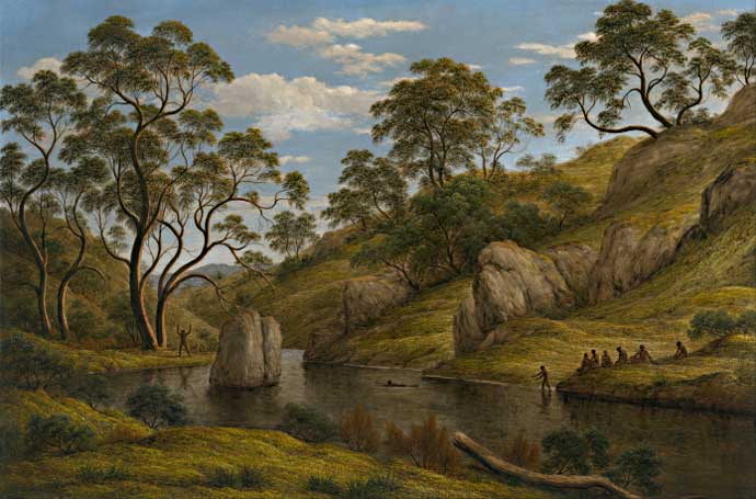
The bath of Diana, Van Diemen's Land (1837) - John Glover landscape artist (UK) 1767-1849


This timeline was produced by Dr. Shayne Breen, Geography & Environmental Studies, University of Tasmania with additional Flinders Island information from Maxine Roughley, CEO – Flinders Island Aboriginal Association Inc.
(BP = year before the present; all dates are approximate)
43,000 BP
The island was joined to mainland Australia by a land bridge between Wilson’s Promontory in Victoria and northeast Tasmania, making it possible for people to walk south to the island
42,000 BP
Aboriginal people were living on the banks of the Jordan River, north of Hobart
40,000 BP
People were living in Parmerpar Meethaner Rock-shelter at the head of the Forth River, and in Warreen Cave in the Maxwell River valley in southwest Tasmania
36,000 BP
The climate briefly warmed and the land bridge was flooded
30,000 BP
The climate began to cool, sea-levels began falling, the land bridge grew in size
27,000 BP
Mannalargenna Cave on Prime Seal Island and Beeton Rock-shelter on Badger Island were first occupied by Aborigines; occupation of both sites continued until 10,000 BP
27,000 BP
People were living in Cave Bay Cave on Hunter Island in northwest Tasmania
23,000 BP
Kutikina Cave in the Franklin River valley, southwest Tasmania, was first occupied; the Franklin and nearby Maxwell River valleys became Ice Age refuges for many Aborigines; wallaby and wombat were the staple meat foods
20,000 BP
People established an ochre mine at Point Hibbs on the southwest coast of Tasmania; sometime later, people began making art with ochre in at least four southwest caves
18,000 BP-15,000 BP
Very slow warming of the climate occurred; the use of Mannalargenna Cave and Beeton Rock-shelter intensified, suggesting either increased population levels or possible migration of people from Victoria
14,000 BP
The climate continued to slowly warm, highland glaciers began melting, sea-levels began to rise, the land bridge was flooded, and the occupation of southwest caves ceased
12,000 BP
The Earth’s orbit tilted, causing rapid climate warming and ending the Ice Age; pollen evidence shows that the regular controlled firing of one million hectares of button-grass plains in western Tasmania had commenced by this date and that regular firing continued until the 1830s; people used the friction method to make fire
10,000 BP
Wetter and warmer conditions encouraged rapid forestation of much of the island, rainforest in the west, eucalyptus in the east; the Warragarra Rock-shelter site was established at the head of the Mersey River; old coastal camp sites were slowly flooded over the following 4,000 years
8,400 BP
Camp sites and controlled firing were established at Rushy Lagoon in northeast Tasmania
8,200 BP
Camp sites and controlled firing were established at Rocky Cape in the northwest
8,000 BP
Wetter and warmer conditions peaked; forests were thicker for the following 3,000 years
7,600 BP
Shell-fish sites were established at Carlton River in the southeast
7,200 BP
Controlled firing was used to clear rainforest near Tarraleah in the central highlands
7,000 BP
Coastal camp sites and controlled firing were established at and near Palana on Flinders Island and at the mouth of the Tamar River
6,000 BP
Camp sites and controlled firing were established at Waterhouse Point in the northeast
6,000 BP
Sea-levels stabilised, the island assumed its present coast, and all older coastal camp sites were now flooded; people lived mostly on a diet of shell-fish, seal, muttonbirds, land mammals & plant foods
5,000 BP
The climate became cooler and drier; forest cover decreased, grasslands increased; new sites were established at oyster grounds on the east and southeast coasts; use of controlled firing increased, and new inland sites in the island’s east and central midlands were established
4,000 BP
Occupation of Flinders Island ceased because in the drier conditions it was too small to support a viable hunter-gatherer population
4-2,000 BP
For 2,000 years the climate was under the influence of an El Nino effect: rainfall was unpredictable and extended droughts occurred
3,500 BP
People engaged in widespread expansion into coastal areas in the northwest, southwest, the north coast hinterland, and on the slopes of the Great Western Tiers
3,500 BP
Scale fish called wrasse or parrot fish, which constituted no more than 5-10% of the diet, developed a disease which made the fish fatally toxic for humans; wrasse were dropped from the diet
3,000 BP
People using bark canoes established new seasonal sites on several off-shore islands, including Hunter and Robbins Islands in the northwest and Maria Island in the east
3,000 BP
Almost the entire island was now occupied; regular firing was used in all parts of the island to reduce bush-fire risk, and to cultivate native grasses for wallaby grazing and root plants for human consumption
1,000 BP
Greater use was made of sub-tidal resources, including abalone and crayfish, at coastal sites; the number of middens continued to grow, suggesting the human population was also increasing
700 BP
Catamarans were invented and used to sail from Louisa Bay to Maatsuyker Island to hunt seals
1642
Abel Tasman noticed Aboriginal fires in southeast Tasmania
1772-1802
French and British sailors made land-fall in southeast Tasmania on eight separate occasions and had interactions, some friendly and some hostile, with local Aborigines
1803-4
British forces occupied Aboriginal land at Risdon Cove; up to 50 Aboriginal men, women and children were killed and others injured in the Risdon Cove massacre
1807-1820s
Aboriginal men were murdered and women and children were regularly abducted by free colonists and convict hunters
1810s-1820s
European sealers and Aboriginal women, some forcibly abducted, established an Aboriginal Islander community on the Furneaux Islands
1817-1828
A million acres of Aboriginal hunting grounds in the north, the centre and the east were given free by government to invading colonists, who stocked the land with a million sheep
1824
The government led by George Arthur began a six-year war against Aborigines who resisted the theft of their lands and the abduction of the women and children; large numbers of Aborigines and smaller numbers of colonists were killed
1826
Resisting Aborigines were classified as enemies of the state and the use of force against them was sanctioned by government
1828
Martial law was declared, which meant Aborigines could be legally shot on sight
1829
G.A Robinson began his ‘friendly mission’ to ‘persuade’ Aboriginal survivors to relocate to a prison camp on the Furneaux Islands
1830
The so-called Black Line convinced surviving Aborigines to accept a false government offer to give them Flinders Island in return for going into voluntary exile
1832-47
Aboriginal survivors of the war were imprisoned at Wybalenna on Flinders Island, where many died from common respiratory diseases
1830s
Mutton-birding became the core economy for the Aboriginal Islander community
1847
Survivors of Wybalenna were removed to vermin-ridden buildings at Oyster Cove, south of Hobart
1850-60s
The Aboriginal Islander community, led by Lucy Beedon, campaigned for land rights and a school on Cape Barren Island (CBI)
1876
Truganini died and the myth of Aboriginal extinction began
1881
A reserve for Aboriginal Islanders was established on CBI
1897
The CBI Aboriginal Association was formed to lobby for self-management on the reserve and control of muttonbird rookeries
1899
Fanny Cochrane Smith recorded songs of her people that she learned as a child at Wybalenna
1909
Royal Society of Tasmania member William Crowther illegally removed the remains of twelve Aborigines from graves at Oyster Cove
1912
The CBI Reserve Act limited citizenship rights for reserve residents
1915
More Tasmanian Aborigines per head of population enlisted in the Great War than from any other place in Australia
1922
An Islander petition to the Government unsuccessfully sought ownership of the reserve
1951
Cape Barren Island Reserve was closed, some Aborigines remained on the island, others moved to Launceston, Burnie and Hobart
1950s-70s
Welfare authorities engaged in forced child removal
1973
The Tasmanian Information Centre, later the Tasmanian Aboriginal Centre (TAC) was formed and began to agitate for land returns, the recognition of identity, and the return of stolen human remains
1973
The Flinders Island Community Association was formed and was later renamed the Flinders Island Aboriginal Association. **
1976
According to her wish, one hundred years after her death, Truganini’s remains were cremated and scattered in the D’Entrecasteaux Channel
1976
Michael Mansell presented a petition to the English Queen seeking land rights
1977
The TAC petitioned parliament for the return of land and compensation for their theft
1982
The TAC mounted a campaign to prevent the flooding of southwest caves by a dam on the Franklin River
1983
Tasmanian Aboriginal Land Council was formed to negotiate with government for heritage protection and land returns
1984
Oyster Cove was occupied by the TAC and claimed as Aboriginal land
1985
Parliament legislated the return of all human remains held in Tasmanian museums to the Aboriginal community; Aborigines began to lobby museums in Europe to return stolen remains
1991
A group of about ten Flinders Island Aborigines re-occupied the Wybaleena site and made it clear that they had reclaimed the area in the name of the Aborigines living on Flinders Island. This was never more evident than with the sign that hung on the gate that read ‘You are now entering Aboriginal land, please respect our culture’. **
1991
The TAC occupied Rocky Cape and claimed it as Aboriginal land; the area was later included in a national park
1991
A land rights Bill was passed in the House of Assembly but rejected by the Legislative Council
1995
A successful land rights Bill, introduced by Ray Groom’s liberal government, returned 3,800 hectares, including Oyster Cove and Risdon Cove, to the Aboriginal community
1997
Tasmania became the first state to formally apologise for forced child removal
1999
Wybalenna was returned to Aboriginal ownership and its role in the genocide of Tasmanian Aborigines was acknowledged by then premier Jim Bacon
1999
ILC purchased Thule Farm on Flinders Island for the Flinders Island Aboriginal Association.
2000
25,000 people walked over Hobart’s Tasman Bridge in support of Reconciliation
2005
Most of Cape Barren Island was returned to Aboriginal ownership, the TAC renamed the island Truwana
2006
The commitment by the Flinders Island Aboriginal Community led the ILC to grant title to the Flinders Island Aboriginal Association, achieving the first Indigenous land ownership on Flinders Island other than housing allotments. **
2006
Tasmania was the first jurisdiction in Australia to legislate to provide compensation to the Stolen Generations and their families. A $5 million fund was created to provide payments to eligible members of the Stolen Generations and their children
2011
Despite strong objections from Aborigines and their supporters, the state government built a major bridge across a 42,000 year old Aboriginal site on the Lower Jordan River
2013
A culturally-rich, 7,000 hectare property in the central highlands called Gowan Brae was returned to Aboriginal community ownership, under a partnership between the Australian government, the Australian Indigenous Land Corporation, the Tasmanian Land Conservancy, the Aboriginal Land Council of Tasmania, and the TAC